- Region
- Águilas
- Alhama de Murcia
- Jumilla
- Lorca
- Los Alcázares
- Mazarrón
- San Javier
-
ALL AREAS & TOWNS
- AREAS
- SOUTH WEST
- MAR MENOR
- MURCIA CITY & CENTRAL
- NORTH & NORTH WEST
- TOWNS
- Abanilla
- Abarán
- Aguilas
- Alamillo
- Alcantarilla
- Aledo
- Alhama de Murcia
- Archena
- Balsicas
- Blanca
- Bolnuevo
- Bullas
- Cañadas del Romero
- Cabo de Palos
- Calasparra
- Camping Bolnuevo
- Campo De Ricote
- Camposol
- Canada De La Lena
- Caravaca de la Cruz
- Cartagena
- Cehegin
- Ceuti
- Cieza
- Condado de Alhama
- Corvera
- Costa Cálida
- Cuevas De Almanzora
- Cuevas de Reyllo
- El Carmoli
- El Mojon
- El Molino (Puerto Lumbreras)
- El Pareton / Cantareros
- El Raso
- El Valle Golf Resort
- Fortuna
- Fuente Alamo
- Hacienda del Alamo Golf Resort
- Hacienda Riquelme Golf Resort
- Isla Plana
- Islas Menores & Mar de Cristal
- Jumilla
- La Azohia
- La Charca
- La Manga Club
- La Manga del Mar Menor
- La Pinilla
- La Puebla
- La Torre
- La Torre Golf Resort
- La Unión
- Las Palas
- Las Ramblas
- Las Ramblas Golf
- Las Torres de Cotillas
- Leiva
- Librilla
- Lo Pagan
- Lo Santiago
- Lorca
- Lorquí
- Los Alcázares
- Los Balcones
- Los Belones
- Los Canovas
- Los Nietos
- Los Perez (Tallante)
- Los Urrutias
- Los Ventorrillos
- Mar De Cristal
- Mar Menor
- Mar Menor Golf Resort
- Mazarrón
- Mazarrón Country Club
- Molina de Segura
- Moratalla
- Mula
- Murcia City
- Murcia Property
- Pareton
- Peraleja Golf Resort
- Perin
- Pilar de la Horadada
- Pinar de Campoverde
- Pinoso
- Playa Honda
- Playa Honda / Playa Paraíso
- Pliego
- Portmán
- Pozo Estrecho
- Puerto de Mazarrón
- Puerto Lumbreras
- Puntas De Calnegre
- Region of Murcia
- Ricote
- Roda Golf Resort
- Roldan
- Roldan and Lo Ferro
- San Javier
- San Pedro del Pinatar
- Santiago de la Ribera
- Sierra Espuña
- Sucina
- Tallante
- Terrazas de la Torre Golf Resort
- Torre Pacheco
- Totana
- What's On Weekly Bulletin
- Yecla


- EDITIONS:
 Spanish News Today
 Alicante Today
 Andalucia Today
The Roman villa of Los Villaricos in Mula
Mula, Villa Romano de Los Villaricos
 The municipality of Mula is the location of a major, large scale Roman agricultural villa in the area of Los Villaricos, close to the banks of the River Mula.
This is one of the most important villas of its kind in the Region of Murcia and is a substantial structure with evidence of several hundred years of occupation. It can be visited by groups on an appointment only basis and is open from time to time for general visits by the public, usually on days coinciding with the monthly artesan market.
Although it is an extensive site, there are still large areas of the villa remaining unexcavated to date.
Contact the tourist office for an appointments and bookings (see Tourist Office Mula).
Historical background
 In 209BC the Iberian Peninsula was subjected to a new influence and catalyst for change: the Roman invasion.
Cartagena (at that point "Qart Hadast") had been under the control of the Carthaginians for 18 years, but during the Second Punic Wars between the Romans and Carthaginians (218-202BC) the Carthaginian general Hannibal left Cartagena defenceless and set off across the Alps with his army and elephants to attack Rome directly.
Seeing an opportunity, the Roman general Publius Cornelius Scipio invaded Cartagena, and the area fell to the Romans. Cartagena became Carthago Nova, a city from which the Romans spread out to conquer southern Spain and which soon grew into a major Roman city.
The Romans were practical conquerors and viewed all their territories dispassionately, simply as a means of generating increased wealth for their own Empire, paying their armies and feeding the city of Rome, the largest in the world at this point in history.
What is now the Region of Murcia offered a source of lucrative raw materials: the hills of the Sierra Minera held minerals which could be smelted to make silver coinage, the hillsides of the north yielded esparto grass which used for cordage and household items, large plains provided wheat to feed the troops which continued to occupy further areas of Spain, and other valuable products included olive oil, marble, sandstone and a coastline which offered opportunities for the production of fish sauces.
 The Romans introduced new farming practices, working alongside the local populations to exploit the resources of the land, and gradually settled into their territories, bringing their own farming model, the villa, to the hillsides of what is now the Region of Murcia.
There are the remains of many Roman villas across the region, the term "villa" being generally understood as a single-family unit for agricultural exploitation on a plot of land of varying size. The villa included a building or a group of buildings which served as both a home for those who worked the land and a workshop and storehouse for the food products which came from the land.
Generally speaking, at the height of the Roman Empire the villas in Hispania were little more than workhouses, run by resident farmhands and visited only occasionally by the owners when increased activity on the farm made it necessary. However, 400 years after invading the Peninsula, starting in the 2nd century AD and especially in the 3rd century, a series of events sparked socio-economic and cultural changes as the Roman Empire underwent a succession crisis and began to crumble.
As this process intensified the structure began to change and more villas became primary residences, their accommodation more sumptuous and extensive.
(A more extensive history of the Roman occupation of the Region of Murcia can be found in the History of Cartagena.)
Development phases of the Roman Villa at Villaricos
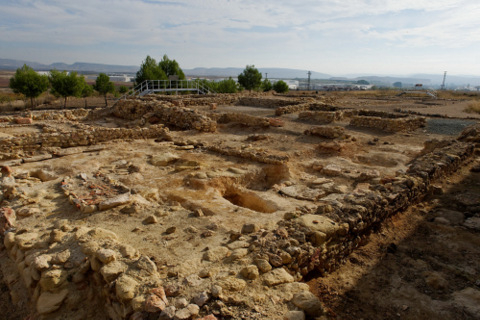 It is clear that this villa continued as a going concern and a family residence for a long time, with four different phases of construction and habitation having been identified.
Phase 1: The first indications of occupancy in the Roman Villa at Villaricos date from the second half of the 1st century AD to the second half of the second century.
At this time there was a marked increase in the numbers of agricultural villas in the Region of Murcia and there are others dating from this period in the same area, although none on the same scale as one or indeed in such a good state of preservation.
Second phase: The late 2nd century to the end of the 3rd century
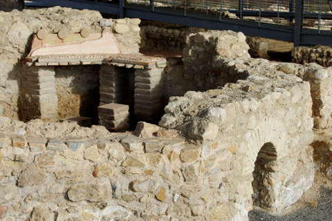
After more than a century of existence the villa was totally modified. Existing structures were demolished and a new one constructed, giving the layout which is visible today. This was the most important era in the life of the settlement and would have been the period at which the villa was at its most splendid and productive: during this phase the thermal baths and large water cistern were built.
Third phase: 4th century to the first half of the 5th century
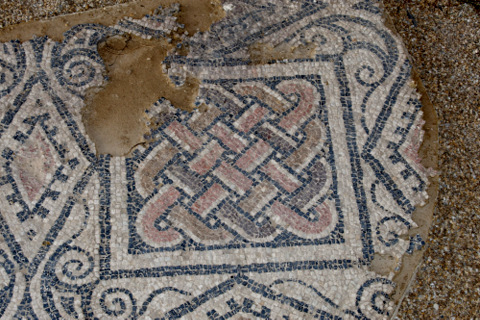
During this phase the mosaic flooring was laid and a number of minor reforms 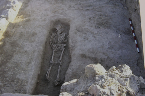 undertaken. There are also indications of modifications made to the production areas of the villa, possibly marking a decline in production.
Fourth phase: late 5th century and early 6th century
This co-incides with the disintegration of the Roman Empire, when the villa was abandoned.
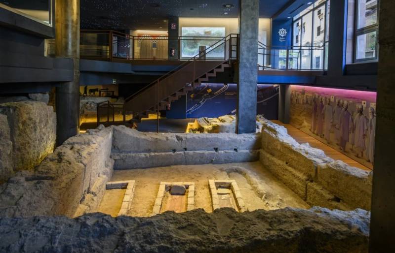
The industrial activities of the villa ceased altogether and only a residual population remained in or near the villa. A separate semi-circular building also relates to this period and was clearly used for religious purposes, and the area immediately around it became an improvised cemetery, or necropolis, with the dead being buried as close as possible to the walls of the building.
Parts of the villa structure were used to house the burials, breaking up the mosaic floors to inter around 50 bodies inside the former residential areas.
These are simple graves, covered with large slabs of sandstone and with the sides supported by smaller stones. Some are decorated with fragments of ceramics and tiles, and they are believed to date from the 5th to the 7th century. Many of the designs include decorative elements typical of Christian iconography.
The structure of a Roman agricultural villa
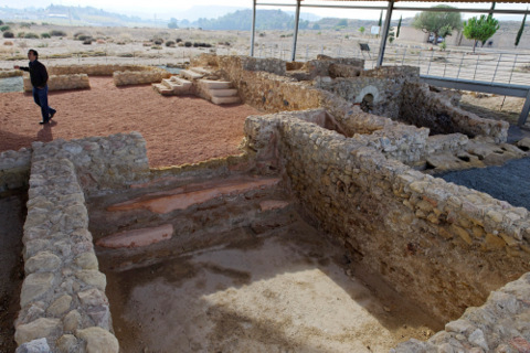 In the 1st century AD the agronomist Columella wrote “De Re Rustica”, in which he divided the typical villa into the following parts:
- the “pars urbana” or “dominica” was the area where the overlord of the property lived with his family, and where guests were received. Sometimes domestic servants also lived here.
The pars rustica included both the dwellings of the slave farmhands and other workers on the land and the area where animals and farming implements were kept. Inside this part was also the “pars frumentaria”, where products were made, preserved and stored.
The Roman Villa of Los Villaricos is very typical, showing separate areas relating to the main residence on one hand and the manufacture and storage of products on the other, the main product in this case being the vital Roman provisions of olive oil and wine. Decorative remains have also been found here, including mosaics, paintings and items fashioned from marble, and these would have satisfied the desire for luxury and comfort of the rich agricultural landowners.
The Baths
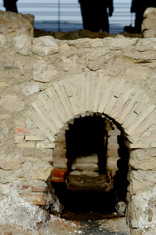 The inclusion of baths (“balnea”) in Roman villas became widespread and almost compulsory throughout Hispania in the 1st and 2nd centuries AD, as it was impossible to make the trip to the nearest town every day to visit the public thermal baths there.
The bathhouse at Los Villaricos consists of two adjoining blocks, the northern one of which housed the cold baths and the southern one the heated rooms and warm baths. The way the baths were organized is typical of the Roman villas: the frigidarium (cold bath), tepidarium (lukewarm bath) and caldarium (hot bath) being laid out almost in a straight line, like a factory floor process. The remaining space is organized to facilitate the movement of bathers from one area to another.
Pars Urbana, residential area
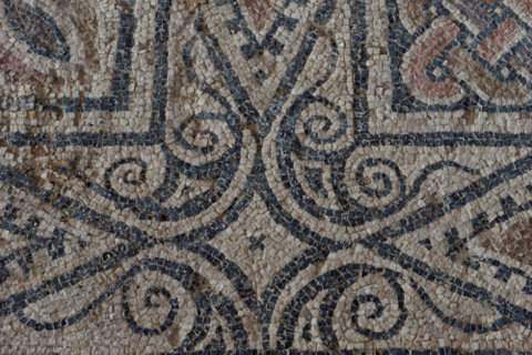 The pars urbana, where the owner and his family lived, is a typical example of Mediterranean house design of the time, with a central patio surrounded by a covered porch from which there was access to all the main rooms. These were the rooms reserved for the owners, who had a similar distribution of their living space in their main residence in the town when they still lived there in the 1st and 2nd centuries. At that time the villa was not only agricultural but also industrial, manufacturing and selling the products derived from the crops.
From the 3rd century onwards, though, the owners lived in the villa permanently and the residence of the owner and his family became a clear indication of his status within the new rural aristocracy in the province, which was to develop throughout Hispania from that time on. The villas thus became houses of nobility, and this is reflected in the quality of the mosaic floors (opus tesselatum), with geometrical decorative designs which are visible in this villa. There are still many mosaics hidden from public view for protection purposes, although there are some sections currently on view.
The olive mill
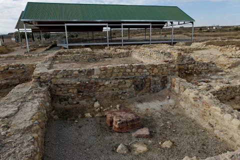 One of the most interesting findings at the site of Los Villaricos is a torcularium (olive mill), the only one to have been systematically excavated in the Region of Murcia so far. The existence of this mill shows the extent to which the rural farms here depended on olive oil production and local trading in order to survive, far from the Lower Guadalquivir where olive farming was on a much larger scale in Roman times.
At the northern end of the central corridor are the structures designed for the production of oil, which, to judge by their size, must have accounted for a large proportion of the villa’s economic activity. A series of rooms were used for pressing, decanting the oil into tanks, and storing in a large deposit known as a “lacus”. All of these rooms were built using cement and rendered with red mortar.
At the far eastern end of the torcularium, room number 6 is a large rectangular storeroom measuring 30 metres by 10 metres. This was used to store the oil once it had been produced, awaiting its transport and sale. The room is divided into three separate areas by a series of limestone pillars from the quarry at Cerro de la Almagra.
The Cistern
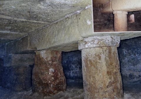 One of the most spectacular discoveries in the villa was the large subterranean cistern which was discovered beneath the floor of one of the main residential rooms. This is the only cistern of its type discovered so far in the Region of Murcia.
It provided 20 cubic metres of storage, measuring 4.5 by 3 metres with a depth of 1.5 metres. It was supported by large rectangular blocks of stone and its walls were sealed off with a waterproof sealing.
Water was collected from the roof of the central patio and funnelled down into the cistern, then distributed as required. Evidence of lead piping has also been discovered inside the cistern.
Burials
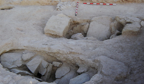 The longevity of the villa inevitably brought about the need for places of burial for its inhabitants. As the years passed it became necessary to choose an area away from the residential buildings, and in the 1990s the remains of a tomb were discovered 100 metres to the north-east, although unfortunately over the centuries part of the contents had been ransacked by thieves.
Further excavation and cleaning revealed it to be a double tomb, each of which had been covered with a stone slab underneath a mound of stones and mortar. Each grave is 50 cm wide, 2 metres long and 65 cm deep, and the two are separated by a wall 25 cm thick, which is finished in slake lime and fine ceramics, giving it a reddish colour. Only a few fragments of bone were found inside them.
Similar tombs have been found in other parts of the Region of Murcia, such as the later part of the burial ground of San Antón in Cartagena, La Molineta (Puerto de Mazarrón) and the centre of Águilas, all of them dating from between the 3rd and 5th centuries AD.
Location
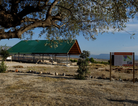 The villa can be clearly seen from the main Autovía del Noroeste, with a covered roof.
The site can be reached from the Autovía del Noroeste (C-415), travelling north-west from Murcia towards Mula and Caravaca.
After 30km turn off towards Mula Centro and Puebla de Mula, and take the MU-530 towards Mula. This passes underneath the motorway, and at the next roundabout take the exit towards the Pantano de la Cierva reservoir. The site is 500 metres along this road.
Click for Villaricos, Mula.


