- Region
- Águilas
- Alhama de Murcia
- Jumilla
- Lorca
- Los Alcázares
- Mazarrón
- San Javier
-
ALL AREAS & TOWNS
- AREAS
- SOUTH WEST
- MAR MENOR
- MURCIA CITY & CENTRAL
- NORTH & NORTH WEST
- TOWNS
- Abanilla
- Abarán
- Aguilas
- Alamillo
- Alcantarilla
- Aledo
- Alhama de Murcia
- Archena
- Balsicas
- Blanca
- Bolnuevo
- Bullas
- Cañadas del Romero
- Cabo de Palos
- Calasparra
- Camping Bolnuevo
- Campo De Ricote
- Camposol
- Canada De La Lena
- Caravaca de la Cruz
- Cartagena
- Cehegin
- Ceuti
- Cieza
- Condado de Alhama
- Corvera
- Costa Cálida
- Cuevas De Almanzora
- Cuevas de Reyllo
- El Carmoli
- El Mojon
- El Molino (Puerto Lumbreras)
- El Pareton / Cantareros
- El Raso
- El Valle Golf Resort
- Fortuna
- Fuente Alamo
- Hacienda del Alamo Golf Resort
- Hacienda Riquelme Golf Resort
- Isla Plana
- Islas Menores & Mar de Cristal
- Jumilla
- La Azohia
- La Charca
- La Manga Club
- La Manga del Mar Menor
- La Pinilla
- La Puebla
- La Torre
- La Torre Golf Resort
- La Unión
- Las Palas
- Las Ramblas
- Las Ramblas Golf
- Las Torres de Cotillas
- Leiva
- Librilla
- Lo Pagan
- Lo Santiago
- Lorca
- Lorquí
- Los Alcázares
- Los Balcones
- Los Belones
- Los Canovas
- Los Nietos
- Los Perez (Tallante)
- Los Urrutias
- Los Ventorrillos
- Mar De Cristal
- Mar Menor
- Mar Menor Golf Resort
- Mazarrón
- Mazarrón Country Club
- Molina de Segura
- Moratalla
- Mula
- Murcia City
- Murcia Property
- Pareton
- Peraleja Golf Resort
- Perin
- Pilar de la Horadada
- Pinar de Campoverde
- Pinoso
- Playa Honda
- Playa Honda / Playa Paraíso
- Pliego
- Portmán
- Pozo Estrecho
- Puerto de Mazarrón
- Puerto Lumbreras
- Puntas De Calnegre
- Region of Murcia
- Ricote
- Roda Golf Resort
- Roldan
- Roldan and Lo Ferro
- San Javier
- San Pedro del Pinatar
- Santiago de la Ribera
- Sierra Espuña
- Sucina
- Tallante
- Terrazas de la Torre Golf Resort
- Torre Pacheco
- Totana
- What's On Weekly Bulletin
- Yecla


- EDITIONS:
 Spanish News Today
 Alicante Today
 Andalucia Today
The ruined castle of Tébar in Aguilas
The castles of Chuecos and Tébar protected the rural population of Águilas as long ago as the 12th century
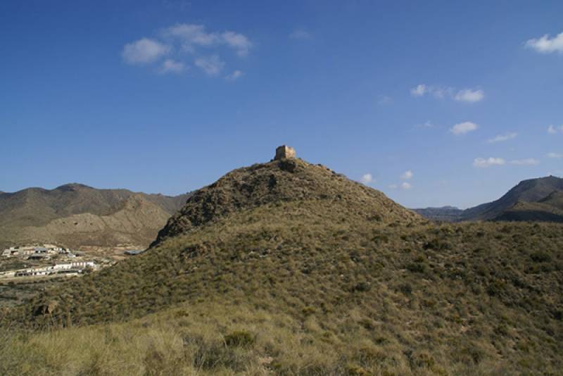 The castle of Tébar stands at an altitude of 486 metres above sea level on a hill next to the old road between Lorca and Mazarrón (click for map), about 12 kilometres from the town of Águilas, and although the road (now the RM-332) is close by it requires something of a hike to reach it from a small rural track. It is a near total ruin but the course of the castle wall can still be seen from the foundation stones, and although the tower at the north-east of the fortification is still partially standing it is in a precarious state.
The castle was first built in the 12th century and there is documented evidence that in 1285 it was occupied by the Castilian forces, who held Aragonese prisoners there. However, shortly afterwards the troops of Aragón took control of both Tébar and the nearby castle of Chuecos, which stands just a couple of kilometres to the north-east but which cannot be seen from here.
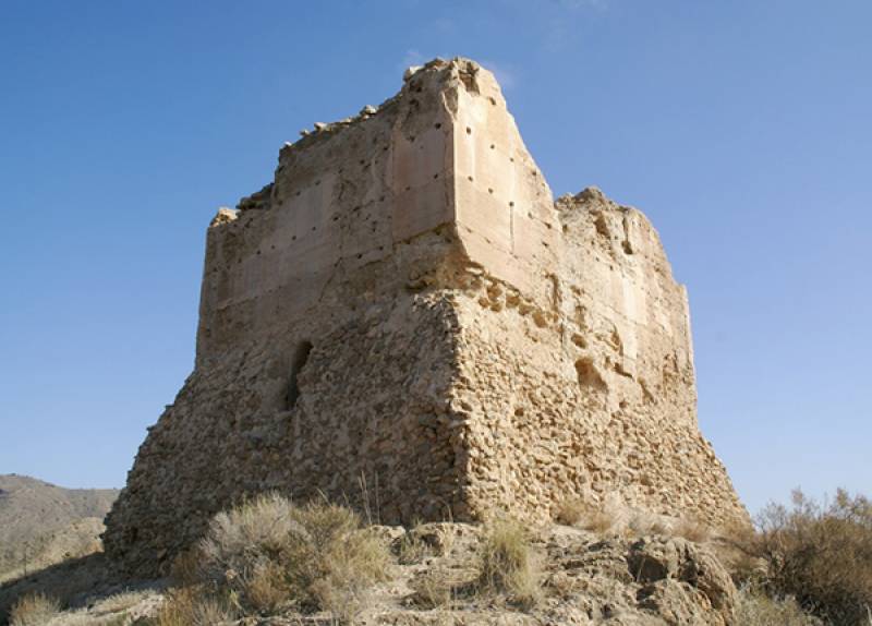 The castle precinct occupied an area of around 5,500 square metres and its odd shape was determined by the lie of the land on the hilltop. It seems that the main access was up the southern slopes of the hill, and of the three towers the one in best condition is the one at the north-eastern part of the fortress. Nowadays it reaches only 8 metres in height but would have been considerably higher in the past, and embrasures and arrow slits can still be seen along with what might have been a machiolation to help defend the castle.
In the 15th century the castles at Tébar and Chuecos served as protection for the handful of Castilian farmers working the land, although they were also used for lighting beacons which warned of any Moorish raids, either by land through Vera, from the nearby border Nazarí kingdom of Granada, or by sea from the north of Africa. This was frontier territory, and the raids by land continued until the expulsion of the Moors from Granada in 1492, while Christian raids were also made in the other direction across the border. The maritime raids by the Berbers continued long afterwards, though, and made the area unsafe. For this reason the coastline of Águilas was not home to a significant population until the 18th century.
The top of the tower was removed (or fell off) at some time in the 15th century, but later on, possibly in the Peninsular War or even the Civil War, the castle was briefly in use again and new embrasures were created.
By the start of the 18th century there was already a small population in the municipality of Águilas, among them the beekeepers and shepherds who took up residence close to the castles in Tébar and Chuecos. This location, close to the defensive fortresses and some way inland from the coast, at least afforded them some protection from possible attacks
When visiting Águilas your first port of call should be the local tourist office (click here for map, telephone 968 493285, email turismo@aguilas.es).
For more local events, news and visiting information go to the home page of Águilas Today.


